Key Points
- India consists of 28 states and 8 union territories as of 2026, totaling 36 administrative entities. This structure has remained stable since the last major reorganization in 2020.
- States are self-governing with their own legislatures, while union territories are centrally administered, though some like Delhi and Puducherry have partial state-like powers.
- Capitals serve as administrative hubs; some regions use dual capitals for seasonal or logistical reasons, reflecting India’s diverse geography.
- Research suggests no new states or territories have been added since 2020, though proposals for further divisions occasionally arise in political discussions.
- The evidence leans toward stability in India’s federal structure, balancing regional identities with national unity, amid ongoing debates about resource allocation and governance.
Overview of India’s Administrative Divisions
India’s federal system divides the country into states and union territories to manage its vast population and cultural diversity effectively. States enjoy greater autonomy, electing their own governments and handling matters like education, agriculture, and law enforcement. Union territories, however, fall under direct central government oversight, often due to strategic importance, small size, or security concerns. This setup evolved through historical reorganizations, primarily based on linguistic, cultural, and administrative needs.
The total remains at 28 states and 8 union territories following key changes: the bifurcation of Jammu and Kashmir into two union territories in 2019, and the merger of Dadra and Nagar Haveli with Daman and Diu in 2020. No further alterations have occurred by 2026, despite occasional calls for new states in regions like Uttar Pradesh or Maharashtra to address developmental disparities.
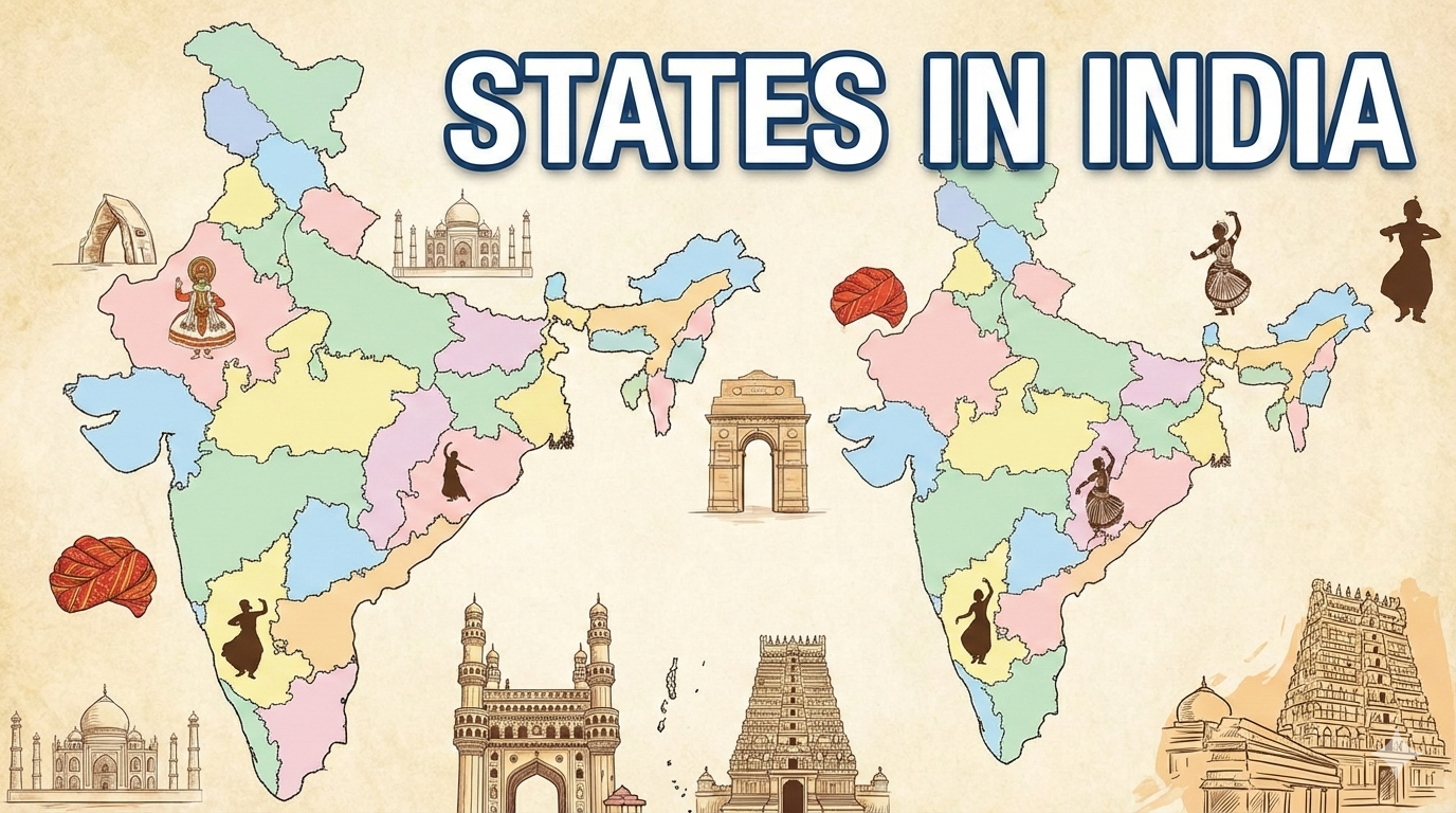
List of States and Capitals
Here is a concise list of the 28 states with their capitals (noting dual capitals where applicable):
- Andhra Pradesh: Amaravati
- Arunachal Pradesh: Itanagar
- Assam: Dispur
- Bihar: Patna
- Chhattisgarh: Raipur
- Goa: Panaji
- Gujarat: Gandhinagar
- Haryana: Chandigarh
- Himachal Pradesh: Shimla (Summer), Dharamshala (Winter)
- Jharkhand: Ranchi
- Karnataka: Bengaluru
- Kerala: Thiruvananthapuram
- Madhya Pradesh: Bhopal
- Maharashtra: Mumbai (Summer), Nagpur (Winter)
- Manipur: Imphal
- Meghalaya: Shillong
- Mizoram: Aizawl
- Nagaland: Kohima
- Odisha: Bhubaneswar
- Punjab: Chandigarh
- Rajasthan: Jaipur
- Sikkim: Gangtok
- Tamil Nadu: Chennai
- Telangana: Hyderabad
- Tripura: Agartala
- Uttar Pradesh: Lucknow
- Uttarakhand: Dehradun (Winter), Bhararisain (Summer)
- West Bengal: Kolkata
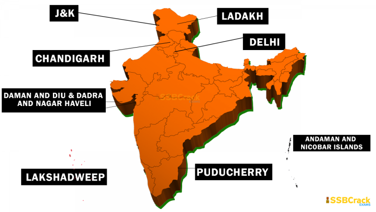
List of Union Territories and Capitals
The 8 union territories and their capitals (with seasonal notes):
- Andaman and Nicobar Islands: Sri Vijaya Puram (formerly Port Blair, renamed in 2024)
- Chandigarh: Chandigarh
- Dadra and Nagar Haveli and Daman and Diu: Daman
- Delhi: New Delhi
- Jammu and Kashmir: Srinagar (Summer), Jammu (Winter)
- Ladakh: Leh (Summer), Kargil (Winter)
- Lakshadweep: Kavaratti
- Puducherry: Puducherry
For more details on population, area, or official languages, refer to official government portals like Know India.
India’s administrative landscape in 2026 reflects a carefully balanced federal republic, comprising 28 states and 8 union territories, for a total of 36 distinct entities. This structure underscores the nation’s commitment to unity in diversity, accommodating over 1.4 billion people across varied terrains, cultures, and economies. While the number has remained unchanged since the early 2020s, understanding its evolution provides insight into India’s dynamic political history. This detailed exploration covers the historical context, current lists with capitals, demographic and geographic highlights, governance nuances, and potential future developments, drawing from reliable sources to ensure accuracy.
Historical Evolution of India’s States and Union Territories
India’s journey to its current administrative setup began post-independence in 1947, when the country inherited a patchwork of princely states and British provinces. The Constitution of India, adopted in 1950, initially recognized 14 states (Part A) and 6 territories (Part C), but rapid reorganizations followed to align boundaries with linguistic and cultural identities.
The landmark States Reorganisation Act of 1956 redrew maps based on language, creating states like Andhra Pradesh (for Telugu speakers) and Kerala (for Malayalam speakers). This reduced chaos from over 500 princely states and set the foundation for modern divisions. Subsequent changes included:
- 1960s-1980s: Formation of Maharashtra and Gujarat (1960), Haryana from Punjab (1966), Himachal Pradesh as a state (1971), and northeastern states like Manipur, Meghalaya, and Tripura (1972) to address ethnic aspirations.
- 2000: Three new states—Uttarakhand (from Uttar Pradesh), Chhattisgarh (from Madhya Pradesh), and Jharkhand (from Bihar)—were carved out for better resource management and development.
- 2014: Telangana split from Andhra Pradesh amid demands for separate statehood, focusing on regional inequities.
- 2019-2020: The most recent shifts occurred with the Jammu and Kashmir Reorganisation Act, 2019, which bifurcated the former state into two union territories: Jammu and Kashmir and Ladakh, effective October 31, 2019. This was driven by security and administrative needs in the sensitive Himalayan region. Additionally, Dadra and Nagar Haveli merged with Daman and Diu on January 26, 2020, to streamline governance in these small coastal enclaves.
By 2026, no further additions or mergers have materialized, despite proposals for new states like Vidarbha (from Maharashtra) or Bundelkhand (from Uttar Pradesh and Madhya Pradesh). These ideas often stem from economic disparities but face hurdles in parliamentary approval. The stability since 2020 highlights a maturing federal system, where the focus has shifted to enhancing existing entities through initiatives like the Aspirational Districts Programme.
Detailed List of 28 States with Capitals, Key Facts, and Significance
States form the backbone of India’s federalism, each with a governor appointed by the president and a chief minister elected by the state legislature. They handle concurrent subjects like education and health while contributing to national policies. Below is a comprehensive table summarizing the 28 states, including capitals, formation dates, populations (approximate as of recent estimates), areas, and notable features. Populations are based on 2024 projections, as the 2021 Census was delayed.
| State | Capital(s) | Formation Date | Population (approx.) | Area (km²) | Official Languages | Key Features |
|---|---|---|---|---|---|---|
| Andhra Pradesh | Amaravati | November 1, 1956 | 53 million | 160,205 | Telugu, Urdu | Known for IT hubs like Hyderabad (shared until 2024) and coastal agriculture; post-Telangana split, focus on new capital development. |
| Arunachal Pradesh | Itanagar | February 20, 1987 | 1.5 million | 83,743 | English | Border state with China; rich in biodiversity, hydropower potential, and indigenous tribes. |
| Assam | Dispur | January 26, 1950 | 35 million | 78,438 | Assamese, Bengali | Tea capital of India; faces flood challenges and ethnic diversity in the Northeast. |
| Bihar | Patna | January 26, 1950 | 130 million | 94,163 | Hindi | Historical cradle of Buddhism; high population density drives migration and development programs. |
| Chhattisgarh | Raipur | November 1, 2000 | 30 million | 135,191 | Hindi | Mineral-rich; focuses on tribal welfare and steel industries. |
| Goa | Panaji | May 30, 1987 | 1.5 million | 3,702 | Konkani, Marathi | Smallest state by area; tourism-driven economy with beaches and Portuguese heritage. |
| Gujarat | Gandhinagar | May 1, 1960 | 70 million | 196,024 | Gujarati, Hindi | Industrial powerhouse; home to the Statue of Unity and vibrant textile sector. |
| Haryana | Chandigarh | November 1, 1966 | 30 million | 44,212 | Hindi | Agricultural hub; shares capital with Punjab, emphasizing urban growth around Delhi. |
| Himachal Pradesh | Shimla (Summer), Dharamshala (Winter) | January 25, 1971 | 7.5 million | 55,673 | Hindi | Himalayan tourism; dual capitals for accessibility in snowy winters. |
| Jharkhand | Ranchi | November 15, 2000 | 40 million | 79,714 | Hindi | Mining heartland; addresses Naxal issues and tribal rights. |
| Karnataka | Bengaluru | November 1, 1956 | 68 million | 191,791 | Kannada | Silicon Valley of India; blends tech with coffee plantations and ancient temples. |
| Kerala | Thiruvananthapuram | November 1, 1956 | 35 million | 38,863 | Malayalam | Highest literacy rate; known for backwaters, spices, and remittance economy. |
| Madhya Pradesh | Bhopal | November 1, 1956 | 86 million | 308,245 | Hindi | Largest state by area; rich in forests, wildlife, and historical sites like Khajuraho. |
| Maharashtra | Mumbai (Summer), Nagpur (Winter) | May 1, 1960 | 126 million | 307,713 | Marathi | Financial capital Mumbai drives GDP; dual capitals for legislative sessions. |
| Manipur | Imphal | January 21, 1972 | 3 million | 22,327 | Manipuri | Northeastern gem; known for classical dance and ongoing ethnic reconciliation efforts. |
| Meghalaya | Shillong | January 21, 1972 | 3.5 million | 22,429 | English | Wettest place on Earth (Cherrapunji); matrilineal societies and coal resources. |
| Mizoram | Aizawl | February 20, 1987 | 1.2 million | 21,081 | Mizo, English | Bamboo economy; high literacy and Christian-majority population. |
| Nagaland | Kohima | December 1, 1963 | 2 million | 16,579 | English | Hornbill Festival hub; focuses on peace accords with insurgent groups. |
| Odisha | Bhubaneswar | January 26, 1950 | 47 million | 155,707 | Odia | Mineral wealth; coastal temples like Konark and cyclone-prone regions. |
| Punjab | Chandigarh | November 1, 1966 | 30 million | 50,362 | Punjabi | Breadbasket of India; Sikh heritage and Green Revolution legacy. |
| Rajasthan | Jaipur | November 1, 1956 | 81 million | 342,239 | Hindi | Desert state; tourism from forts and palaces, plus solar energy push. |
| Sikkim | Gangtok | May 16, 1975 | 0.7 million | 7,096 | Nepali, English | Smallest population; organic farming leader and Himalayan biodiversity. |
| Tamil Nadu | Chennai | November 1, 1956 | 78 million | 130,058 | Tamil | Manufacturing and IT corridor; ancient Dravidian culture and temples. |
| Telangana | Hyderabad | June 2, 2014 | 38 million | 112,077 | Telugu, Urdu | Newest state; pharma and tech boom in Hyderabad. |
| Tripura | Agartala | January 21, 1972 | 4 million | 10,486 | Bengali, Kokborok | Border with Bangladesh; gas resources and tribal harmony initiatives. |
| Uttar Pradesh | Lucknow | January 26, 1950 | 240 million | 243,286 | Hindi | Most populous; Ganges heartland with agriculture and political influence. |
| Uttarakhand | Dehradun (Winter), Bhararisain (Summer) | November 9, 2000 | 11 million | 53,483 | Hindi | Pilgrimage sites like Haridwar; dual capitals for mountainous terrain. |
| West Bengal | Kolkata | January 26, 1950 | 100 million | 88,752 | Bengali | Cultural hub; deltas, tea gardens, and industrial revival in Kolkata. |
This table highlights India’s regional contrasts, from densely populated plains to sparse mountainous areas.
In-Depth on Union Territories: Governance and Unique Roles
Union territories differ from states in lacking full legislative autonomy, with the central government appointing administrators (lieutenant governors). However, Delhi, Jammu and Kashmir, and Puducherry have elected assemblies and chief ministers, granting them “partial state” status. This hybrid model addresses unique needs, such as Delhi’s role as the national capital or Ladakh’s strategic border position.
Here’s a detailed table for the 8 union territories:
| Union Territory | Capital(s) | Formation Date | Population (approx.) | Area (km²) | Official Languages | Key Features |
|---|---|---|---|---|---|---|
| Andaman and Nicobar Islands | Sri Vijaya Puram (renamed from Port Blair in 2024) | November 1, 1956 | 0.4 million | 8,249 | Hindi, English | Island archipelago; biodiversity hotspots, tribal reserves, and naval importance. |
| Chandigarh | Chandigarh | November 1, 1966 | 1.2 million | 114 | Hindi, Punjabi, English | Planned city by Le Corbusier; serves as capital for Haryana and Punjab. |
| Dadra and Nagar Haveli and Daman and Diu | Daman | January 26, 2020 (merger) | 0.6 million | 603 | Gujarati, Hindi | Coastal enclaves; industrial growth post-merger for efficiency. |
| Delhi (National Capital Territory) | New Delhi | February 1, 1992 (NCT status) | 31 million | 1,483 | Hindi, English, Punjabi, Urdu | Political and economic center; ongoing center-state power debates. |
| Jammu and Kashmir | Srinagar (Summer), Jammu (Winter) | October 31, 2019 | 13 million | 42,241 | Dogri, Kashmiri, Hindi, Urdu, English | Post-reorganization focus on development; tourism in valleys and security. |
| Ladakh | Leh (Summer), Kargil (Winter) | October 31, 2019 | 0.3 million | 59,146 | Hindi, English | High-altitude desert; Buddhist heritage, solar potential, and border tensions. |
| Lakshadweep | Kavaratti | November 1, 1956 | 0.07 million | 32 | Malayalam, English | Coral islands; eco-tourism and fisheries; smallest UT by area. |
| Puducherry | Puducherry | November 1, 1954 | 1.6 million | 492 | Tamil, French, English | Former French colony; beaches, spiritual centers like Auroville. |
These territories often serve strategic purposes, like naval bases in Andaman or trade ports in Daman. Their smaller size allows centralized management, but calls for statehood (e.g., in Delhi) persist due to growing populations.
Demographic, Economic, and Cultural Insights
With a population exceeding 1.4 billion, India’s divisions facilitate targeted governance. Uttar Pradesh tops state populations at around 240 million, while Sikkim is the least populous. Union territories like Delhi rival mid-sized states in density. Economically, states like Maharashtra and Tamil Nadu contribute heavily to GDP through industry, while union territories like Chandigarh excel in per capita income.
Culturally, this setup preserves linguistic diversity—over 22 official languages across entities. Challenges include interstate water disputes (e.g., Cauvery between Karnataka and Tamil Nadu) and migration pressures, but successes like Kerala’s health model or Gujarat’s industrial zones demonstrate effective federalism.
Potential Future Changes and Controversies
While stable in 2026, proposals for new states continue. Regions like Purvanchal (eastern Uttar Pradesh) or Saurashtra (western Gujarat) seek separation for better representation, but experts caution against fragmentation, which could strain resources. Climate change impacts, such as rising seas threatening Lakshadweep, may prompt administrative tweaks. Political debates often highlight empathy for regional aspirations while stressing national cohesion—research suggests smaller states can boost development but require careful planning.
In summary, India’s 28 states and 8 union territories embody a resilient framework, evolving from colonial legacies to a modern democracy. For the latest updates, consult official sources like the Ministry of Home Affairs.