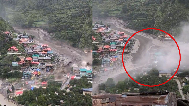
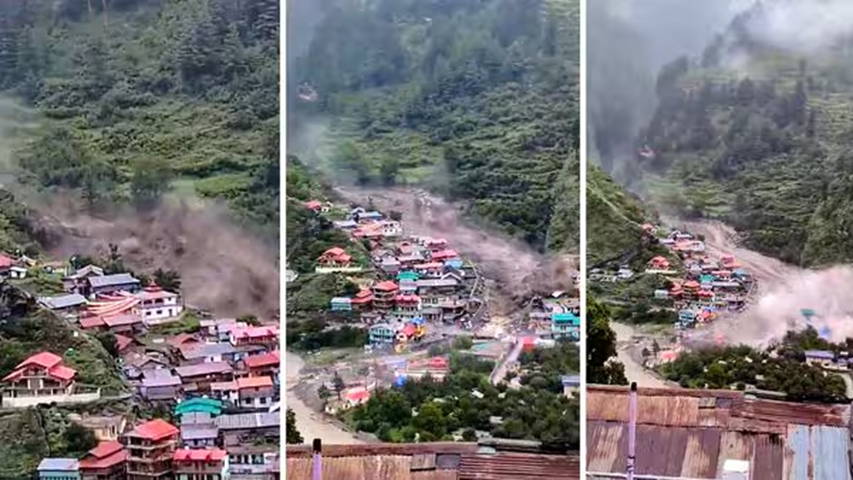
Five people have died and at least 50 are missing after a cloudburst struck Uttarakhand’s Uttarkashi district. This triggered a mudslide and flash floods in Dharali village, a home to several hotels, restaurants and homestays. Visuals of flash floods showed houses falling flat like a deck of cards and being swept away. Local residents could be heard crying for help.
What Caused Uttarkashi Flash Floods ?
Why In News
- Five people have died and at least 50 are missing after a cloudburst struck Uttarakhand’s Uttarkashi district. This triggered a mudslide and flash floods in Dharali village, a home to several hotels, restaurants and homestays. Visuals of flash floods showed houses falling flat like a deck of cards and being swept away. Local residents could be heard crying for help.
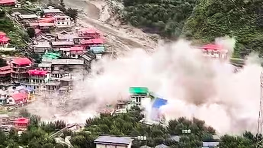
- “According to initial reports, around 40-50 houses have been washed away, and more than 50 people are estimated to be missing,” Mohsen Shahedi, the DIG of the National Disaster Response Force, said. Earlier in the day, the District Magistrate had confirmed four casualties. An Armed Forces camp in the lower Harsil area was also struck by a flash flood soon after, with officials saying around 10 soldiers are reported missing
Topography Of Uttarkashi
- Uttarkashi district is located at a high elevation ranging between 800 and 6,900 metres above mean sea level. Large geographical areas are covered with snow throughout the year, and there are glaciers in many parts of the district. It has the upper reaches of the Ganga and Yamuna rivers, and contains their snowbound source region near Gangotri and Yamunotri respectively.
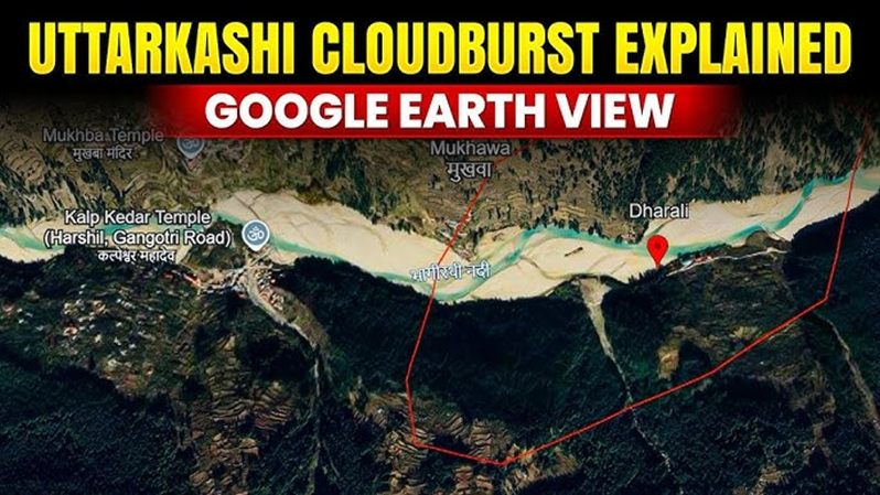
- There are also a series of high ridges, perennial rivers, and valleys in Uttarkashi. The rugged topography of the district features sharp undulations due to high mountains, narrow valleys, and deep gorges. The land slopes steadily towards the southwest, where the elevation in some valleys dips sharply — by as much as 800 metres.
Flash Floods
- Flash floods are not uncommon in the upper hilly areas of Uttarakhand as they are often triggered by a cloudburst — a localised but intense rainfall activity. However, a cloudburst, in a technical sense, did not lead to flash floods on Tuesday, though most parts of the state received heavy rainfall over the past three days.
- The primary reason is the topography of the area, where heavy rainfall often results in landslides, sending mud and concrete into the rivers. These materials flow down with great force, accumulating momentum on the way, leading to flash floods downstream. Early assumptions blamed a cloudburst for the destruction in Uttarkashi, a region frequently battered by intense monsoon events. However, recent meteorological and satellite data tell a different story.
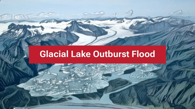
Could It Be A Glacial Lake Outburst
- Scientists now suggest that a sudden release of water from a glacial lake or a glacier collapse upstream could have been the real trigger, leading to an avalanche of debris and water rushing down the Kheer Gad stream and inundating Dharali village. This scenario is reminiscent of the Raini disaster in Chamoli in 2021, where a rock-ice avalanche similarly unleashed a catastrophic flood downstream.
- According to the India Meteorological Department (IMD), rainfall recorded on August 4 and 5 was between 8 to 10 millimetres. Retired scientist and glaciologist Dr. D.P. Dobhal spoke to aajtak.in, stating that the parameters required to classify the event as a cloudburst were not met. “A cloudburst typically means over 100 mm of rainfall in an hour,” he explained. “However, IMD data shows that only 8–10 mm of rain was recorded from the night of August 4 till 8:30 AM on August 5. The flash flood occurred later in the afternoon, suggesting that a cloudburst was likely not the cause.”
- On the other hand, Shardul Gusain, District Disaster Management Officer of Uttarkashi, said that three cloudburst incidents were officially recorded — in Dharali, Harsil, and near Sukhi Top. “Initial indications point to cloudbursts as the trigger,” he said, adding, “More clarity is expected once new data arrives in the morning. At this point, we cannot rule anything out. The weather was relatively calm the previous day, with only light rainfall. But in the mountains, the weather can change in an instant.”
What Is A Glacial Lake Outburst
- A glacial lake outburst flood occurs when water dammed by glacial ice or a moraine breaks free, releasing millions of cubic metres of water in a matter of hours to days.
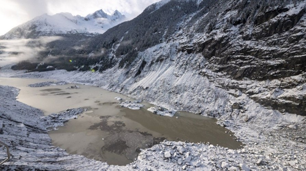
- Such floods are rapid, powerful, and capable of destroying everything in their paths—villages, roads, bridges, and power plants. These events are particularly concerning for Uttarakhand, which contains more than 1,260 glacial lakes, some flagged as high-risk by India’s disaster management authorities.
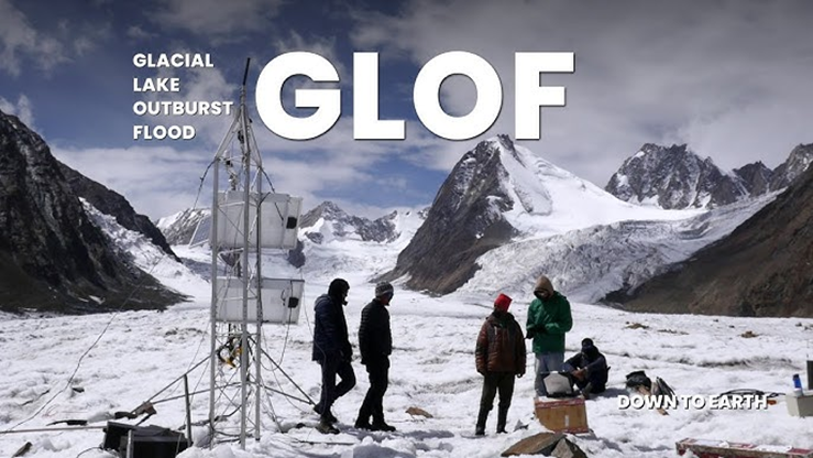
- 13 most vulnerable glacial lakes catagorised as risk level A by National Disaster Management Authority (NDMA) are in Uttarakhand. The lakes are prone to GLOFs, the kind of events that have resulted in several disasters in the Himalayan states in the recent years.
- As rescue operations continue and the scientific investigation deepens, the tragedy in Uttarkashi points to the growing risks posed by climate-driven glacial changes in the fragile Himalayas. Enhanced real-time monitoring of high-altitude glacial lakes and early warning systems are now more critical than ever for the safety of downstream communities.