Key Points
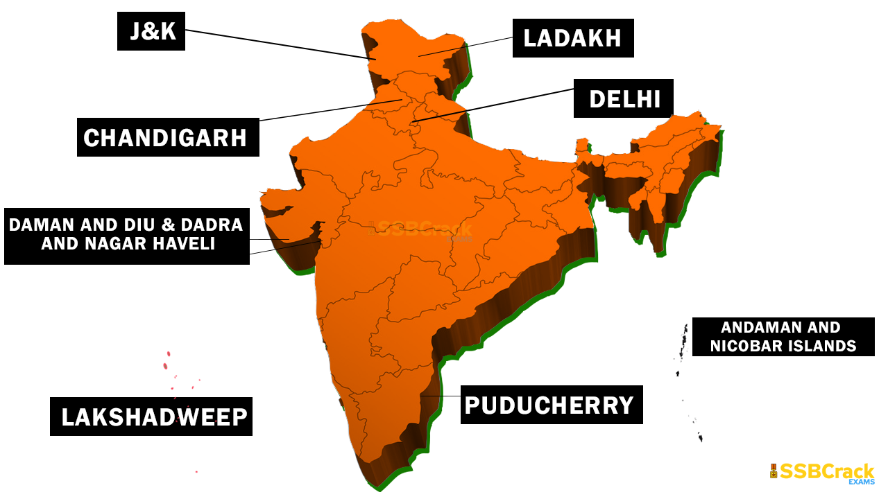
- India has 8 Union Territories (UTs) as of 2026, which are federally administered regions without full statehood, though three (Delhi, Puducherry, and Jammu and Kashmir) have elected legislatures and partial autonomy.
- These UTs vary widely in size, population, and geography, from island archipelagos to urban enclaves, and play key roles in India’s strategic, economic, and cultural landscape.
- Research suggests the structure remains stable post-2019 reorganization, with no major changes despite occasional proposals for statehood or mergers; evidence leans toward continued federal oversight for administrative efficiency.
- The UTs highlight India’s diversity, with some facing unique challenges like climate vulnerability in islands or border tensions in northern regions, while others drive urban innovation.
Overview of India’s Union Territories
Union Territories are administrative divisions directly governed by the central government, often due to strategic importance, small size, or historical reasons. Unlike states, they lack full sovereignty but can have limited self-governance. As of 2026, the 8 UTs cover a combined area of about 112,372 km² and house over 50 million people, contributing significantly to tourism, trade, and national security. Delhi stands out as the most populous and economically vibrant, while island UTs like Lakshadweep and Andaman emphasize maritime interests.
Key Statistics Table
Here’s a comparative overview of the 8 UTs based on the latest available data:
| Union Territory | Capital | Area (km²) | Population (2011 Census / 2024 Est.) | Literacy Rate (2024) | HDI (Recent) |
|---|---|---|---|---|---|
| Andaman and Nicobar Islands | Sri Vijaya Puram | 8,249 | 380,581 / ~434,000 | 91.1% | 0.706 (2022) |
| Chandigarh | Chandigarh | 114 | 1,055,450 / ~1,200,000 | 93.7% | 0.794 (2023) |
| Dadra and Nagar Haveli and Daman and Diu | Daman | 603 | 585,764 / ~700,000 | 87.8% | N/A |
| Delhi (National Capital Territory) | New Delhi | 1,484 | 16,787,941 / ~21,588,000 | 93.7% | 0.794 (2023) |
| Jammu and Kashmir | Srinagar (Summer), Jammu (Winter) | 42,241 | 12,267,013 / ~13,500,000 | 82.0% | 0.760 (2023) |
| Ladakh | Leh (Summer), Kargil (Winter) | 59,146 | 274,289 / ~300,000 | 81.0% | N/A |
| Lakshadweep | Kavaratti | 32 | 64,473 / ~70,000 | 97.3% | 0.719 (2022) |
| Puducherry | Puducherry | 483 | 1,247,953 / ~1,500,000 | 92.7% | 0.741 (2022) |
Population estimates are projected based on growth trends; literacy and HDI reflect recent surveys, acknowledging data limitations in remote areas.
Role and Challenges
UTs serve critical functions: Delhi as the national capital hosts government institutions, while northern UTs like Jammu and Kashmir and Ladakh secure borders amid geopolitical tensions. Island UTs bolster maritime defense and ecology. Challenges include administrative dependency, environmental risks (e.g., rising seas in Lakshadweep), and calls for greater autonomy, as seen in recent Ladakh protests. It seems likely that ongoing developments, like infrastructure boosts, will enhance connectivity, but evidence from border regions highlights persistent security concerns.
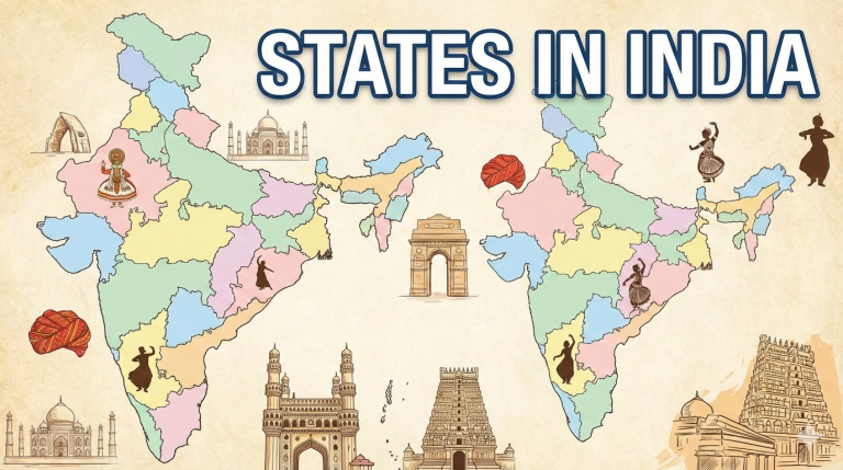
India’s Union Territories represent a fascinating mosaic of the country’s administrative, cultural, and geographical diversity. Unlike the 28 states, these 8 regions are directly overseen by the central government, often due to their strategic locations, small populations, or historical legacies. This detailed exploration, updated to 2026, delves into each UT’s history, geography, governance, economy, demographics, culture, and tourism, drawing on the latest available data and developments. While stable in number since the 2019 reorganization, these territories continue to evolve amid national priorities like infrastructure, sustainability, and security.
Andaman and Nicobar Islands
The Andaman and Nicobar Islands, a group of 836 islands (only 31 inhabited), form India’s easternmost UT in the Bay of Bengal.
History
Human presence dates back over 30,000 years to the Middle Paleolithic era, with indigenous tribes like the Andamanese isolated for millennia. Civilization evidence from 2,200 years ago includes Chola naval bases in the 11th century. The Danish established a colony in 1755, sold to the British in 1868, who built penal settlements like the infamous Cellular Jail (1906) for freedom fighters. Japanese occupation during WWII (1942-1945) involved atrocities and renaming to Shaheed-Dweep and Swaraj-Dweep under Subhas Chandra Bose. Post-1947, it became a union territory in 1956. The 2004 tsunami caused over 2,000 deaths. In 2024, the capital was renamed Srivijayapuram from Port Blair to shed colonial ties.
Geography
Spanning 8,249 km², the islands are divided into northern Andamans (6,408 km²) and southern Nicobars (1,841 km²), separated by the Ten Degree Channel. Located between the Bay of Bengal and Andaman Sea, coordinates are 11°41′N 92°43′E. Highest point: Saddle Peak (732 m). Tropical climate with 23–31°C temperatures and monsoon rains; prone to cyclones. Biodiversity-rich with 86% forest cover, 2,200 plant species (200 endemic), and fauna like dugongs and Andaman wood pigeons. Includes 9 national parks and 96 wildlife sanctuaries.
Administration
Governed by Lieutenant Governor Devendra Kumar Joshi, with Chief Secretary Chandra Bhushan Kumar. Divided into three districts: South Andaman (capital Srivijayapuram), North and Middle Andaman (Mayabunder), and Nicobar (Car Nicobar). Has a Pradesh council since 1981; one Lok Sabha seat under Calcutta High Court (Port Blair Bench). Official languages: Hindi and English.
Economy
2021-22 GDP: ₹103 billion (US$1.2 billion), per capita ₹275,757 (US$3,300). Agriculture (50% workforce) focuses on rice, coconuts, and spices on 6% arable land. Fishing yields 27,526 tonnes annually. Small industries: 1,833 units in engineering and textiles. Tourism: Over 400,000 visitors (2016), contributing via beaches and parks. ANIIDCO promotes development; exclusive economic zone: 0.6 million km².
Demographics
2011 population: 380,581 (density 46/km²); 2019 estimate: 434,192. Urban 37.7%, rural 62.3%. Sex ratio: 876 females/1,000 males. Literacy: 91.1% (2024). Religions: Hinduism (69.45%), Christianity (21.28%), Islam (8.52%). Languages: Bengali (28.49%), Tamil (15.20%), Telugu (13.24%), Hindi (12.91%). Indigenous tribes: Andamanese, Nicobarese, Shompen (declining populations, e.g., Sentinelese ~15). HDI: 0.706 (2022).
Culture
Motto: Satyameva Jayate. Symbols: Andaman wood pigeon (bird), Pyinma (flower), dugong (mammal), Andaman padauk (tree). Indigenous cultures: Andamanese and Nicobarese languages. Majority Hindu with Christian influences. Featured in literature like Sherlock Holmes’ The Sign of the Four and films like Kaala Paani.
Tourism
Attractions: Cellular Jail, Ross Island, Radhanagar Beach, Havelock Island, Mahatma Gandhi Marine National Park. Activities: Scuba diving, kayaking. Restricted Area Permits for foreigners; tribal areas off-limits. Over 400,000 visitors in 2016; NITI Aayog’s 2018 infrastructure plans ongoing.
Chandigarh
Chandigarh, a planned city, serves as the capital for Punjab and Haryana while being a UT itself.
History
Built post-1947 Partition as Punjab’s new capital after Lahore went to Pakistan. Jawaharlal Nehru envisioned it as a modern symbol. Planning began in 1948; Le Corbusier redesigned it in 1951 with a grid and sectors. Inaugurated in 1953. Became a UT in 1966 post-Punjab reorganization. Rock Garden, created by Nek Chand in 1957, opened in 1976. Indus Valley artifacts found in excavations.
Geography
At 30°45′N 76°47′E, spans 114 km² near Shivalik foothills (elevation 321 m). Borders Haryana and Punjab; part of Chandigarh Capital Region with Panchkula and Mohali. Humid subtropical climate: Hot summers (up to 46.7°C), mild winters (down to 0°C), 1,038 mm rainfall. Biodiversity: Deer, parrots, peacocks; Sukhna Lake (3 km², 1958) and Rose Garden (Asia’s largest).
Administration
Governed by Administrator Gulab Chand Kataria (2024). Municipal Corporation with 35 wards (AAP and BJP 14 each post-2021). One Lok Sabha seat. Shares Punjab and Haryana High Court. Official languages: English, Hindi. Utilities: 24×7 water pilot (2021); 550 TPD waste plant (2025).
Economy
2023–24 GDP: ₹0.49 trillion (US$6 billion), per capita ₹430,119 (US$5,100). Wealthiest town; services dominant (IT at Rajiv Gandhi Technology Park). Government major employer; “Pensioner’s Paradise.”
Demographics
2011 population: 1,055,450 (density 9,262/km²). Literacy: 93.7% (2024). Languages: Hindi (67.8%), Punjabi (22.0%). Religions: Hinduism (80.71%), Sikhism (13.11%), Islam (4.87%). HDI: 0.794 (2023).
Culture
“City Beautiful” from Garden City movement. Festivals: Rose Festival, Chandigarh Carnival. Symbols: Indian grey hornbill (bird), dhak (flower), mango (fruit). UNESCO site: Capitol Complex (2016).
Tourism
Attractions: Sukhna Lake, Rock Garden, Rose Garden, Capitol Complex, Japanese Garden. Ranked for cleanliness (2024).
Dadra and Nagar Haveli and Daman and Diu
This merged UT combines former Portuguese enclaves.
History
Merged in 2020 from Dadra and Nagar Haveli (Portuguese 1779–1961) and Daman and Diu (1520s–1961). Annexed by India in 1961; Portugal recognized in 1974. Merger aimed at efficiency.
Geography
603 km² at 20°25′N 72°50′E. Four entities: Dadra enclave, Nagar Haveli (C-shaped), Daman coastal enclave, Diu island. Elevation 0–425 m. Two wildlife sanctuaries.
Administration
Administrator; capital Daman, largest city Silvassa. Three districts. Under Bombay High Court. Official languages: Hindi, Gujarati.
Economy
Data limited; focuses on industry and tourism.
Demographics
2011 population: 585,764 (density 970/km²). Literacy: 87.8% (2024). Religions: Hinduism (92.4%), Islam (5.50%).
Culture
Limited details; blends local and Portuguese influences.
Tourism
Vanganga Garden, St. Thomas Church, Diu Fort, Damanganga River, St. Paul’s Church, Naida Caves.
Delhi (National Capital Territory)
India’s capital, a bustling metropolis.
History
Ancient roots in Indraprastha; capitals of Sultanate, Mughals, British. Partition influx post-1947; UT in 1956, NCT in 1992. Events: 1984 riots, 2001 attack, 2020 violence.
Geography
1,484 km² at 28°36′36″N 77°13′48″E. Yamuna River; seismic zone-IV. Polluted capital (2024); hot semi-arid climate.
Administration
Lieutenant Governor Vinai Kumar Saxena; Chief Minister Rekha Gupta (2025). MCD with 12 zones. Madras High Court? Wait, Delhi High Court.
Economy
2023–24 GSDP: ₹1.11 trillion (US$130 billion). Services, IT, tourism dominant.
Demographics
2011: 16.8 million; 2024 est: 21.6 million. Literacy: 93.7% (2024). Religions: Hinduism (81.68%), Islam (12.86%).
Culture
UNESCO sites: Qutub Minar, Humayun’s Tomb, Red Fort. Festivals: Diwali, Eid. Cuisine: Mughlai, street food.
Tourism
India Gate, Lotus Temple, Jama Masjid; hosted 2023 G20.
Jammu and Kashmir
Northern UT with disputed borders.
History
Princely state until 1947; reorganized 2019. Insurgency 1980s–2000s; Article 370 abrogated.
Geography
42,241 km²; valleys, Himalayas. Cold arid climate.
Administration
Lieutenant Governor Manoj Sinha; Chief Minister Omar Abdullah (2024). 20 districts.
Economy
2025–26 GDP: ₹2.88 lakh crore. Horticulture, tourism.
Demographics
2011: 12.3 million. Literacy: 82.0% (2024). Religions: Islam (68.8%), Hinduism (28.8%).
Culture
Handicrafts, music; sports: cricket, skiing.
Tourism
Srinagar, Gulmarg; 23 million visitors (2024).
Ladakh
High-altitude desert UT.
History
Ancient Zhangzhung; Namgyal dynasty; part of J&K until 2019 UT status.
Geography
59,146 km²; Himalayas, lakes. Fauna: snow leopards.
Administration
Lieutenant Governor Kavinder Gupta. New districts 2024.
Economy
Tourism (500,000+ visitors 2022); agriculture limited.
Demographics
2011: 274,289. Literacy: 81.0% (2024). Religions: Buddhism (40%), Islam (46%).
Culture
Tibetan influences; thukpa, polo.
Tourism
Pangong Lake, monasteries; adventure trekking.
Lakshadweep
India’s smallest UT, coral islands.
History
Chera control; Islam 7th century; Portuguese, British rule; UT 1956.
Geography
32 km² archipelago; tropical climate.
Administration
Administrator; single district, Kavaratti capital.
Economy
Fishing, tourism, coir.
Demographics
2011: 64,473. Literacy: 97.3% (2024). Mostly Muslim (96.58%).
Culture
Jeseri language; Islamic-South Indian blend.
Tourism
Scuba, beaches; permits required.
Puducherry
Former French colony with enclaves.
History
French 1674–1954; UT 1963; renamed 2006.
Geography
483 km²; four districts, coastal.
Administration
Lieutenant Governor Kuniyil Kailashnathan; Chief Minister N. Rangaswamy.
Economy
2023-24 GDP: ₹0.39 trillion. Fisheries, tourism.
Demographics
2011: 1.25 million; 2021 est: 1.69 million. Literacy: 92.7% (2024).
Culture
French-Tamil blend; Auroville.
Tourism
Beaches, Ashram, temples.