


India has accomplished Asia’s first demonstration of performance-based navigation for helicopters on a flight from Juhu to Pune utilising GAGAN satellite technology. Jyotiraditya Scindia, Minister of Civil Aviation, praised it as an example of the “Indian aviation sector blazing a trail in innovation!” Here’s everything you need to know about GAGAN satellite technology, which is likely to revolutionise Indian aviation as the country accomplishes important milestones in the field of Air Navigation Services (ANS).


What Is GAGAN?
GAGAN (GPS Aided GEO Augmented Navigation) is an Indian Satellite-Based Augmentation System (SBAS) developed in collaboration with the Indian Space Research Organisation (ISRO). It is the first system of its kind devised for India and its tropical neighbours. The GAGAN System was certified by the Directorate General of Civil Aviation (DGCA) in 2015 for Approach with Vertical Guidance (APV 1) and en-route (RNP 0.1) operations. It should be mentioned that the world only has four Space-Based Augmentation Systems: India (GAGAN), Europe (EGNOS), Japan (MSAS), and the United States (WAAS). GAGAN is the first system of its kind built for India and its tropical neighbours.
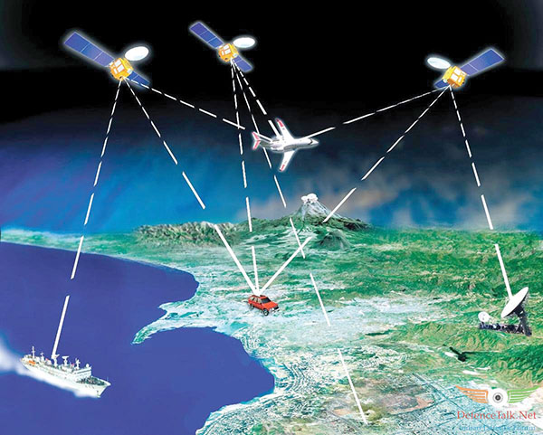
The GAGAN adds the precision, availability, and integrity needed for users to rely on GPS for all phases of flight, from en route to approach, for all eligible airports within the GAGAN service volume. GAGAN also enables more accurate position reporting, allowing for more uniform and high-quality Air Traffic Management (ATM). Furthermore, GAGAN serves all kinds of transportation, including ships, trains, highways, and public services such as defence, telecommunications, security, and personal users of position location apps.
Working of GAGAN
According to the Airports Authority of India (AAI), GAGAN employs a ground station network to supplement the GPS standard positioning service (SPS) navigation signal.
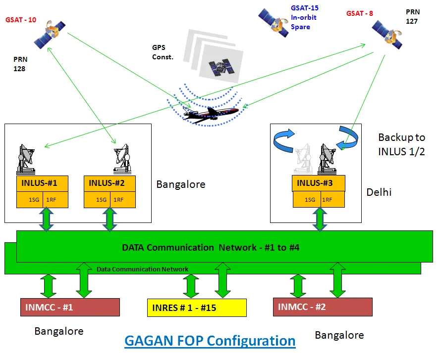
To collect GPS satellite data, a network of precisely surveyed ground reference stations (Indian Reference Stations- INRES) is strategically positioned across the country. The master control centre (Indian Master Control Centre- INMCC) generates messages based on this information to fix any signal faults. These correction messages are subsequently uplinked via the Indian Land Uplink Station (INLUS) and disseminated via communication satellites (Geostationary) to receivers onboard aeroplanes utilising the same frequency as GPS.

To crack the SSB Interview and join the Indian Army as an Officer, You can join our SSB interview live classes batch and we recommend you to Enroll SSB INTERVIEW ONLINE COURSE. Trusted by thousands of defence aspirants.
Also read:

